Traffic congestion on the R44, the main transport artery flowing through Stellenbosch, might soon be a thing of the past thanks to collaboration between two of the town's anchor institutions, the University and the Municipality.
A master's degree student at Stellenbosch University (SU), Mr Wilko Mohr, is developing a sophisticated and tailor-made real-time computerised control system with cameras to synchronise traffic signals along this busy corridor. And he is doing so on a postgraduate bursary funded by Stellenbosch Municipality.
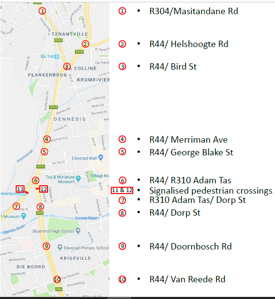 The project will initially cover eight intersections on the busiest stretch of the R44, from Helshoogte Road at Cloetesville in the north to the Van Reede Street crossing at Rhenish Primary School in the south. The pilot phase might be extended to cover another two intersections and two signalised pedestrian crossings. The aim is to test the system in the first quarter of 2019, before eventually rolling it out across town.
“Traffic congestion has become a major problem for us. We are working on various solutions and are fortunate to have the University on our doorstep. In essence, we would like to provide a 'living laboratory', where researchers can come up with solutions to the challenges of our town and surrounds," Stellenbosch Municipality's Director: Infrastructure Services, Mr Deon Louw, said at a Rector-Mayor Forum meeting on 12 October 2018.
In this instance, the Municipality's partner is the Stellenbosch Smart Mobility Lab (SSML), a unit of SU's Department of Civil Engineering that is headed by Dr Johann Andersen, who specialises in intelligent transport systems, supported by Mrs Megan Bruwer, a lecturer in Transport Engineering and Mohr's supervisor.
“Our longstanding collaboration with the Municipality is a great way for us to expose our students to real-life challenges in order to prepare them for the world of work. Plus, they are actually making a positive impact with the research and practical work they do," Andersen said.
He explained the workings of the system: “A combination of new cameras at intersections and existing electromagnetic loops beneath the road surface will detect traffic volume and flow. This data is then fed into the system, which will automatically adjust the traffic signals to get the traffic moving optimally, based on an algorithm that Wilko is refining. What makes this different from existing systems is that human intervention will be minimised."
This will be the first application in Africa of software developed by the PTV Group, a German company widely regarded as a global leader in the field. The new system will link up with the existing traffic light controllers supplied by Syntell, a South African technology company. The data used for the computer modelling is partially being provided by the international navigation company TomTom. All of these firms are industry partners of the SSML.
Mohr is excited to be working on the project: “With a problem such as traffic congestion, a 'hard engineering' solution would be to build more roads, but 'soft engineering' could potentially have the same impact, only much faster and more affordably. Real-time traffic adaptive signal control holds significant potential for developing countries."
The PTV software is being operated successfully in countries such as Germany and Dubai. Yet the only comparable setting to South Africa where it has been piloted is India, along a 3 km route with six signalised intersections on Lodhi Road in Delhi. There, average travel time has decreased by 26%, and queue length by 37%.
CAPTIONS:
Top: Stellenbosch University master's student Wilko Mohr (left) and Stellenbosch Municipality's Deon Louw at a traffic light on one of the intersections in the R44 through town where a new traffic flow system will be piloted. PICTURE: JUSTIN ALBERTS
Above: The section of the R44 to be covered in the pilot, indicating the position of the intersections that will be included, plus possibly another two intersections and two signalised pedestrian crossings. MAP: SUPPLIED
